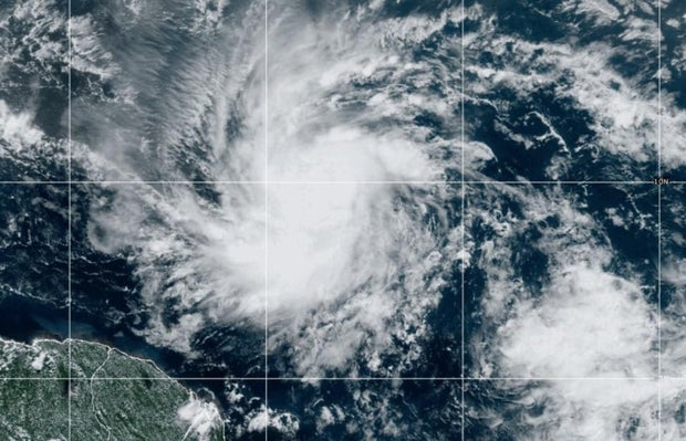
Beryl became the first named hurricane of the 2024 Atlantic hurricane season on Saturday as it inches towards the southeast Caribbean, where it is forecast to bring high winds and torrential rains.
Forecasters warned Beryl is expected to strengthen into a dangerous major hurricane before reaching Barbados and the Windward Islands late Sunday or early Monday. Brian McNoldy, a tropical meteorology researcher for the University of Miami, told the Associated Press that warm waters are fueling Beryl, with ocean heat content in the deep Atlantic the highest on record for this time of year.
Beryl is the first hurricane in more than fifty years to appear before July 4th in the Atlantic basin. Alma hit the Florida Keys on June 8, 1966, according to Weather Underground.
NOAA
Where is Hurricane Beryl headed?
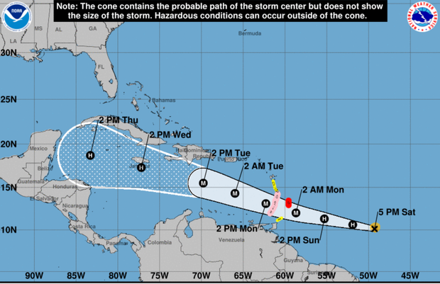
As of Saturday night, Beryl was located about 660 miles southeast of Barbados, moving west at speeds of 22 mph, according to National Hurricane Center. It had maximum sustained winds of 80 mph.
Beryl’s center was forecast to pass about 26 miles south of Barbados, Sabu Best, director of the island’s meteorological service, told the AP.
CBS News weather producer David Parkinson said Beryl is the farthest east a hurricane has formed in the month of June. Only one other hurricane formed this far east in June — and that was in 1933.
NOAA
The center of Beryl is expected to move across the Windward Islands — which includes Grenada, Martinique, Saint Lucia, Dominica and St. Vincent — by late Sunday night or early Monday, according to the hurricane center, bringing “life-threatening winds and storm surge.”
Beryl is forecast to become a major hurricane before it reaches the Windward Islands, according to the hurricane center. As of Saturday evening, Beryl was a Category 1, which is a hurricane with maximum sustained winds of up to 95 mph. When a hurricane reaches Category 3 status — which means maximum sustained winds of 111 mph or higher — it is defined as a major hurricane.
Where will Hurricane Beryl bring rain and flooding?
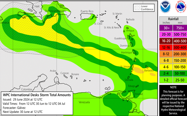
Beryl is forecast to drop anywhere from 3 to 6 inches of rain in Barbados and the Windward Islands, and bring a storm surge of up to seven feet.
St. Vincent is expected to get up to 6 inches of rainfall. Martinique, Grenada, and Dominica are expected to receive 2 to 4 inches of rain. Beryl is expected to bring life-threatening winds and a storm surge to the Windward Islands starting Sunday night.
NOAA
Barbados, St. Lucia, St. Vincent, Granada and the Grenadine Islands are all under a hurricane warning. Martinique and Tobago are under a tropical storm warning, while Dominica is under a tropical storm watch.
Any U.S. impacts are still at least eight days away, Parkinson said, and Beryl is expected to remain south of Jamaica.
— David Parkinson and the Associated Press contributed to this report.


